Adena Trace
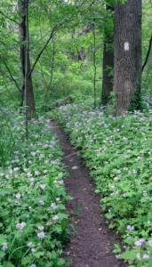
Ablaze with bright pink Redbud in the spring and the vibrant colors of mature maple and oak forests in the fall, the Adena Trace offers some of the finest Midwest scenery. Following along the banks of the Brookville Reservoir of mid-eastern Indiana, the Adena Trace is a rugged and remote foot path which never leaves its hiker bored. It frequently alternates between the calm, cool stillness of the ravines and the high, windy ridge tops with distant views beyond the water. Obtaining backcountry water sources is never a problem

Up-close views of the lush vegetation along the remote Wolf Creek Trail has many interesting creatures
with the lake so near to the trail. In addition to the Redbuds, the spring also brings blankets of flowered areas all along the path, including Waterleaf, Spring Cress, and Virginia Bluebells.
The Adena Trace is 25 miles total in length and forms a complete circle around the southern half of Brookville Lake. In 2002 volunteers with the Hoosier Hikers Council and the American Hiking Society constructed the new Woodlands Trail to replace a portion on the east side of the reservoir that borrowed a road. Throughout 1998 and 2001 the HHC constructed the 11-mile Wolf Creek Trail on the western half of the lake, which completed the 25-mile loop in place today.
The Wolf Creek Trail is very remote, and does not cross or pass any roads, buildings, or houses in its entire 11-mile length from the southern dam to the Fairfield causeway. While its ruggedness and isolation is a definite plus for many backpackers, the down side is that the hiker needs to be prepared, and will also have to hurdle some of those large trees which occasionally fall down the steep ravines toward the lake and its many feed streams.
Along the Adena Trace camping is allowed only in the designated drive-in campground located on the east side of the lake. For this reason, the most feasible overnight backpacking trip on the Adena would begin on the western side. If a backpacker starts in the west, the first day’s hike would head toward the eastern side where the campgrounds are located. The following day one can complete the loop by hiking back to the start at the western side. But this itinerary would be considered strenuous and is recommended only for experienced and fit backpackers.
The DNR provides a public parking lot to access Wolf Creek Trail on the western side. It is a small gravel lot near the end of Keeler Road. Below is a link to a GoogleMap designating this location. The Midway Trail starts at this parking lot, and heads east until it intersects the Wolf Creek Trail.
The HHC offers a fairly low resolution map of the Adena Trace, but it does clearly show the route of the trail and has some topographical information.
Here is a GPS track of the entire Adena Trace loop and the Midway Trail, in standard gpx format: Right-click here and select “Save As”.
If your browser tries to save the file as xml, add “.gpx” to the end of the filename.
The DNR and Army Corps of Engineers manage the areas of this trail, and it is recommended that you visit their website for more hiking or contact information. Please be aware that the DNR trail descriptions have erroneous mileages. GPS tracking shows the following mileages for the different sections of the Adena Trace:
Midway Trail 1.17 miles
Wolf Creek Trail 10.72 miles
Dam Section 0.64 miles
East Side Trails of the Adena Trace 13.38 miles
Fairfield Causeway Section 0.56 miles
The total length of the Adena Trace (excluding the Midway Trail) is 25.3 miles.
As mentioned above, the isolation of the Wolf Creek Trail presents challenges in terms of trail maintenance. If you would be interested in helping to maintain this trail, contact us about the Adena Adopt-a-Trail program!
Downloadable Adena Trace Maps:
Andrew Gustin has created and donated updated, detailed maps of the Adena Trace. We are offering low and high resolution pdf versions of these maps through the links below. To download a map, right click on a link and choose “Save link as…” from the pop-up menu. Be aware that the high-resolution maps could take a while to download depending on your internet connection speed. Choose the map that best suits your needs!
Two-part (north and south), low-resolution map for 8 1/2″ x 11″ paper (1.6 mb)
Two-part (north and south), high-resolution map for 8 1/2″ x 11″ paper (47 mb)
One-page, high-resolution map for 11″ x 17″ paper (40 mb)
Also, Andrew’s map can be viewed offline with a smartphone, and GPS navigation can also be used with it in Firefox. This means that if a hiker loads the map into their phone before the hike, they can locate themselves on the map even if there is no reception. See Andrew’s website for more details: http://free.geopoi.us/#trails.
Google Maps Showing Wolf Creek Trail Parking:
Causeway Parking Lot (north):
https://goo.gl/maps/RmSHUBe1t6JVcjSd6
Midway Trail Parking Lot:
https://goo.gl/maps/pyyuAnEriJtysM9W8
Dam Parking Lot (southwest, below dam):
https://goo.gl/maps/yjfWKWg59fs2uf1d6
Dam Parking Lot (southeast, at top of dam):
https://goo.gl/maps/fJsZ8HGss7Ju51jW7


